一起行山闖蕩去

MacLehose Trail (Section 10)

MacLehose Trail (Section 10)  Login can add to my Favorite

 2019-03-03
 Total Views: 79,291     (Last Updated︰2021-09-13)
 Map 「MacLehose Trail (Section 10)」路線Map
View :
Difficulty :
Path :
Length : 15.2km
Time : 4hours
【 Tin Fu Tsai Campsite 】
Toilet : Outhouse, Portable Toilets
Water : Stream Water
Ascent : 815m  Descent : 1,001m  Max : 237m  Min : 10m<br><p class='smallfont'>The accuracy of elevation is +/-30m

Ascent : 815mDescent : 1,001m
Max : 237mMin : 10m
(The accuracy of elevation is +/-30m)  
Section :
 
Trail 20%
Road 80%
Slope :
 
Ascent 815m (45%)
Descent 1,001m (55%)
Sunlight :
 
80%
Climb :
 
 
Start Point :
NIL 
Support :
 
 
End Point :
港鐵 Bus Minibus Taxi 
 ©2025 TimHiking.com


The starting point is at the Tin Fu Tsai camping site.


 ©2025 TimHiking.com
On the left is the Kat Hing Bridge, which was rebuilt in the 1950s.


 ©2025 TimHiking.com
Along the steps up the mountain,


 ©2025 TimHiking.com
After looking at the dam, continue down the wide concrete road.


 ©2025 TimHiking.com
After walking for about an hour, finally there is the first bifurcation.


 ©2025 TimHiking.com
To leave Tai Lam Chung Country Park,


 ©2025 TimHiking.com


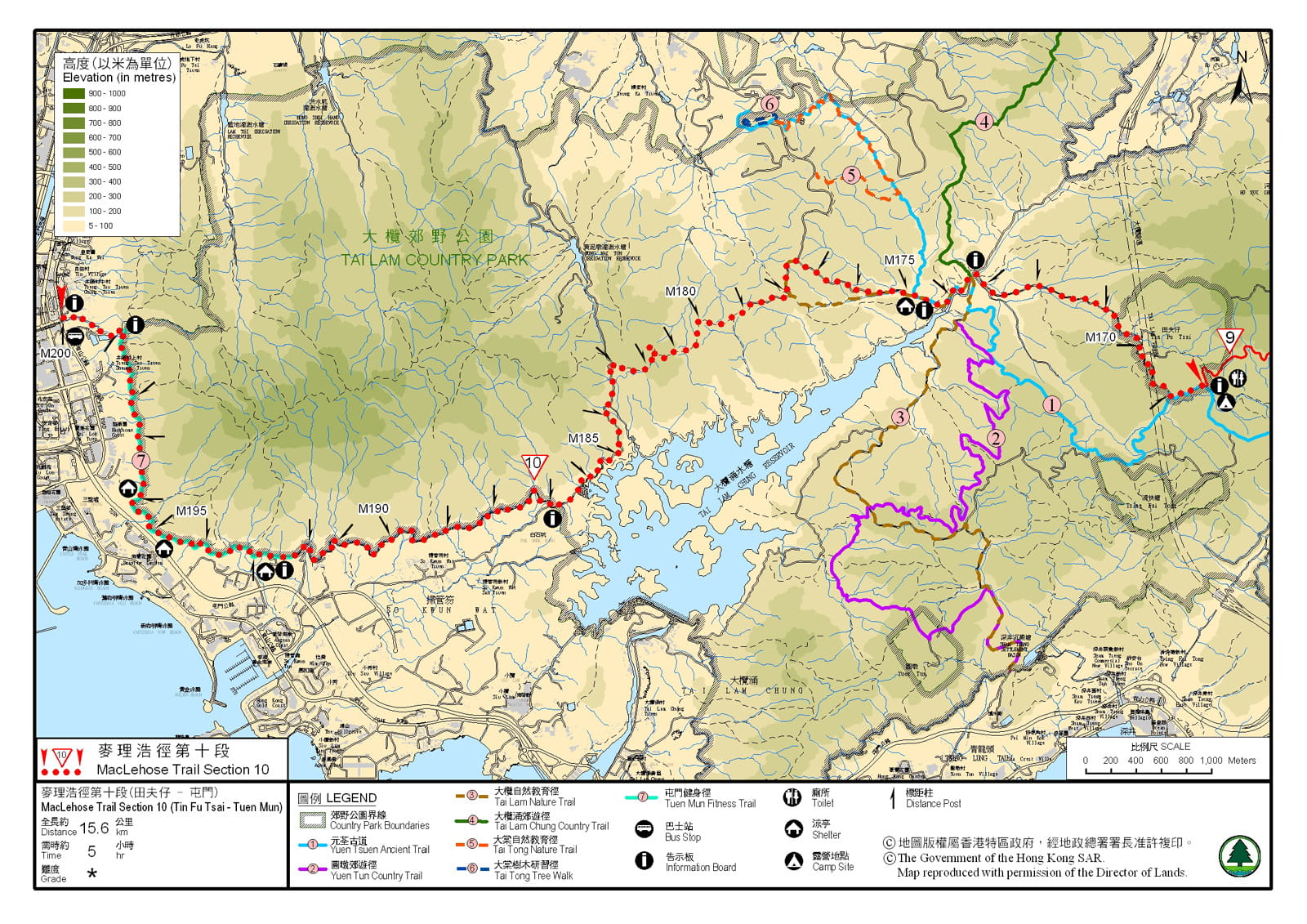
TimHiking【MacLehose Trail (Section 10)】Hiking Route Map


Official Map

Official Map
Antenna :Timsir您好!一個月前行了劏大魚,由343燈塔-分流56燈塔耗時11小時54分(Without Poe)。為了適應走超長線,最近還再次挑戰鳳凰徑1日全走(不過之前尚未試過走這種長距離路線,所以輕鬆走,爬完後完全不累),耗時15小時40分。我還在路跑方面進行了一點訓練:5K 19:55,10K 42:55。最近打算挑戰麥徑全走,請問難度,通常完成時間和前兩條路線的比較,以及能不能在22小時完成?Thanks (2025-02-28)
 
我感覺你可以18-20小時完成麥100,加油! (Tim Sir 2025-02-28)
John Lau :Hello timhiking, 你好,請問麥理浩徑第10段有沒有原始路線?
我曾經聽行山人士說這段麥10是已經更改路線。真的嗎?
(2021-10-21)
 
麥理浩徑第10段(舊路),其實就是最貼大欖涌水塘北面的越野單車徑,亦即M174-M186的改道。 (Tim Sir 2021-10-21)

Alias:      Email: 
   

😄
* Photos can only be personal or landscape photos, and group photos are authorized for portrait rights by default. In addition, headshots, dangerous shots, or photos containing promotional elements are not accepted.
* The shared content may be published after revision. The content must be absolutely positive. If it does not meet the standards, the content will be deleted.
* The message will be approved within one day, and the final decision-making authority will be reserved for TimHiking.

 Thanks a lot! Hope our hiking information is helpful to you. Everyone is happy to go hiking and safely!
 Welcome to use  Payme   AlipayHK  to sponsor Tim Sir's efforts! Continue to give selflessly for the mountain world.

Gold may not be given for it, or a weight of silver in payment for it.

Job 28:15 BBE