| View : |  | ||
| Difficulty : |  | ||
| Path : | |||
| Length : | 9.2km | ||
| Time : | 4hours | ||
 | |
| Ascent : 737m | Descent : 647m |
| Max : 919m | Min : 392m |
| (The accuracy of elevation is +/-30m) | |


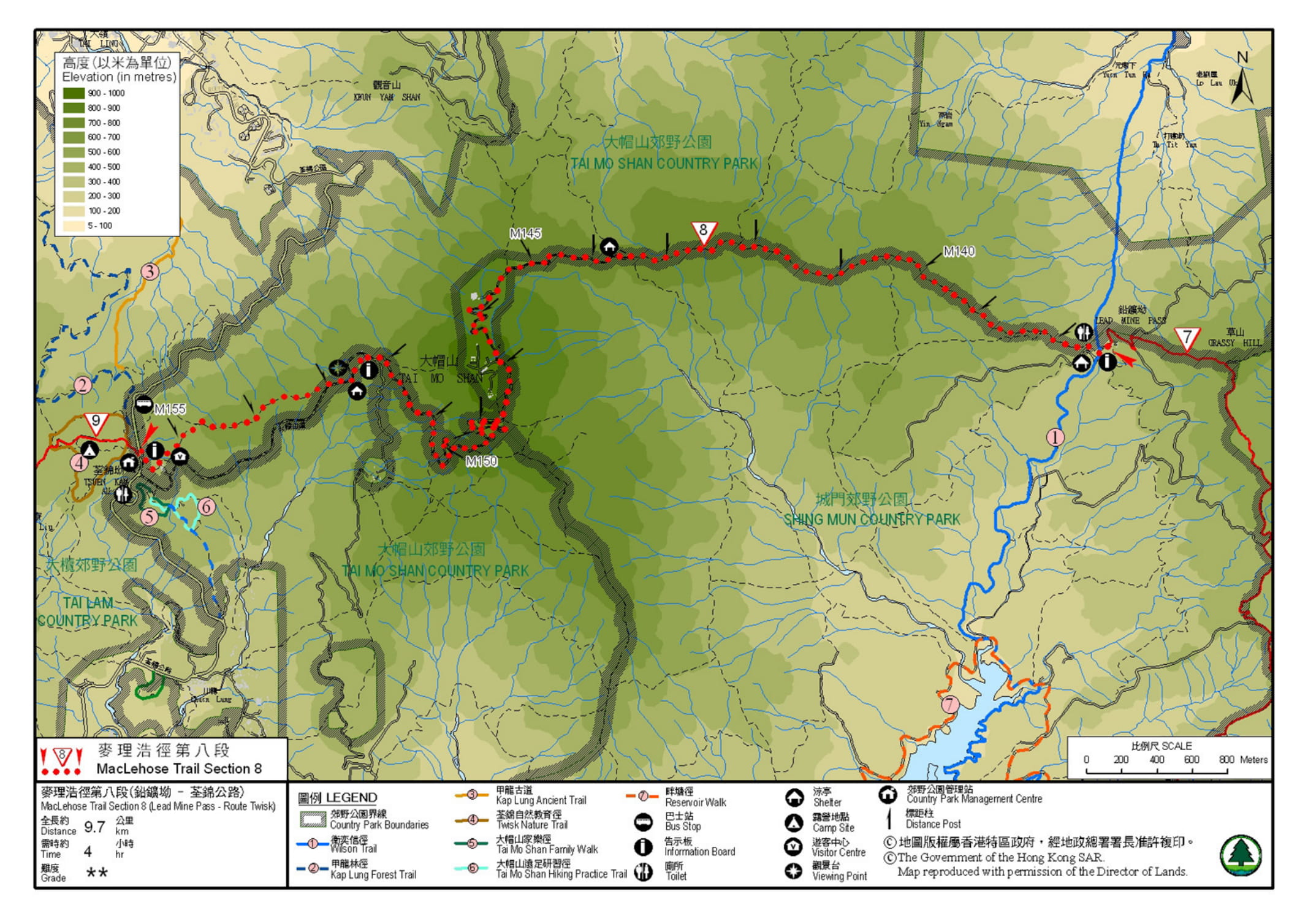
Official Map


| View : |  | ||
| Difficulty : |  | ||
| Path : | |||
| Length : | 9.2km | ||
| Time : | 4hours | ||
 | |
| Ascent : 737m | Descent : 647m |
| Max : 919m | Min : 392m |
| (The accuracy of elevation is +/-30m) | |


| Happyjos : | 今日剛剛行完,我五十後大嬸覺得,八段比起我上次四+五段行得容易,完成時間都比你預定的快,好意外,謝謝你的分享,我會繼續行埋九段同十段,問題係,單行九段會太短,九+十一齊行會唔會太辛苦? 仲有,網頁版,你個 messager pop up 不停跳出黎, close 完都會再出現,有無得 check 下 (2022-01-20) |
那是官方的完成時間,並非我們的預計時間。麥9-10一齊行是沒問題的,基本上都是平坦石屎路一條,只是長一點而已。至於,Message PopUp問題,那是 facebook植入的,我們不能控制,正常按「X」Close 就可關閉。 (Tim Sir 2022-01-20) |
| Gideon : | 請問若在四方亭(四方山坳)脫出,以下那條路線較好? 1)向北走,經雞公頭,然後行一大段天梯下降至萬德苑,最後行至梧桐寨. 2)向南走,經四方山南脊,南房肚,大城石澗徑,龍門郊遊徑,最後行至城門水塘. (2021-11-10) |
脫出,就當是撤退,當然以短以快為先。 1) 落梧桐寨天梯不經瀑布是最快的; 2) 而大城石澗徑就有點太長,因為落到底還要走半個水塘才到小巴站。 (Tim Sir 2021-11-11) |
| Mei : | Tim sir你好, 請問現在去大帽山睇芒草啱時間嗎?還是遲些去較好? (2021-11-09) |
大東剛出,未爆植,也未變白,約過多一、兩星期啦。 (Tim Sir 2021-11-09) |
| snow : | 請問如果我跟依條路,由怡翠山莊上鉛礦坳,這段路要行多少時間? (2021-10-20) |
因人而異,天梯不斷,可參考一下【衛奕信徑第7段(後半部份)】 (Tim Sir 2021-10-20) |
| EL : | 請問馬路會唔會有好多車?🙇🏻♀️ (2020-10-26) |
假日山頂處經常塞車 (Tim Sir 2020-10-26) |
| Henry Li : | 你好,此路線的出口應為荃錦公路而非粉錦公路,相信為手文之誤。 (2020-07-02) |
已更改,謝謝!如發現有其他錯誤,請繼續提出。 (Tim Sir 2020-07-03) |
| chowfai : | 麥徑我跟弟兄姊妹完成了頭七段了,只餘下 8 - 10,第八段起始點好唔方便,想問問: 如果八、九一齊行,完成第九,有沒有靠近的出口? 第八段由城門出發,到鉛礦坳要多久? (2020-05-05) |
麥八最近是經衛7逆向上山,不過都唔易,因為要不斷上山。反而,經由城門環塘到麥八會比較輕易,路況平緩很多,會比行衛七快。至於,麥九離開的話,可選擇清快塘,即深井。 (Tim Sir 2020-05-05) |
| Janus : | 你好,請問鉛礦坳營地的洗手間有沖身設備嗎? (2020-02-25) |
印象中沒有 (Tim Sir 2020-02-25) |
Thanks a lot! Hope our hiking information is helpful to you. Everyone is happy to go hiking and safely!
Welcome to use Payme AlipayHK to sponsor Tim Sir's efforts! Continue to give selflessly for the mountain world.
He has forgiveness for all your sins; he takes away all your diseases;
Psalms 103:3 BBE
一起爬山闖蕩去 | timhiking | timhiking | timhiking | Message Board | Disclaimer