一起行山闖蕩去

MacLehose Trail (Section 4)

MacLehose Trail (Section 4)  Login can add to my Favorite

 2018-04-06
 Total Views: 151,849     (Last Updated︰2021-09-13)
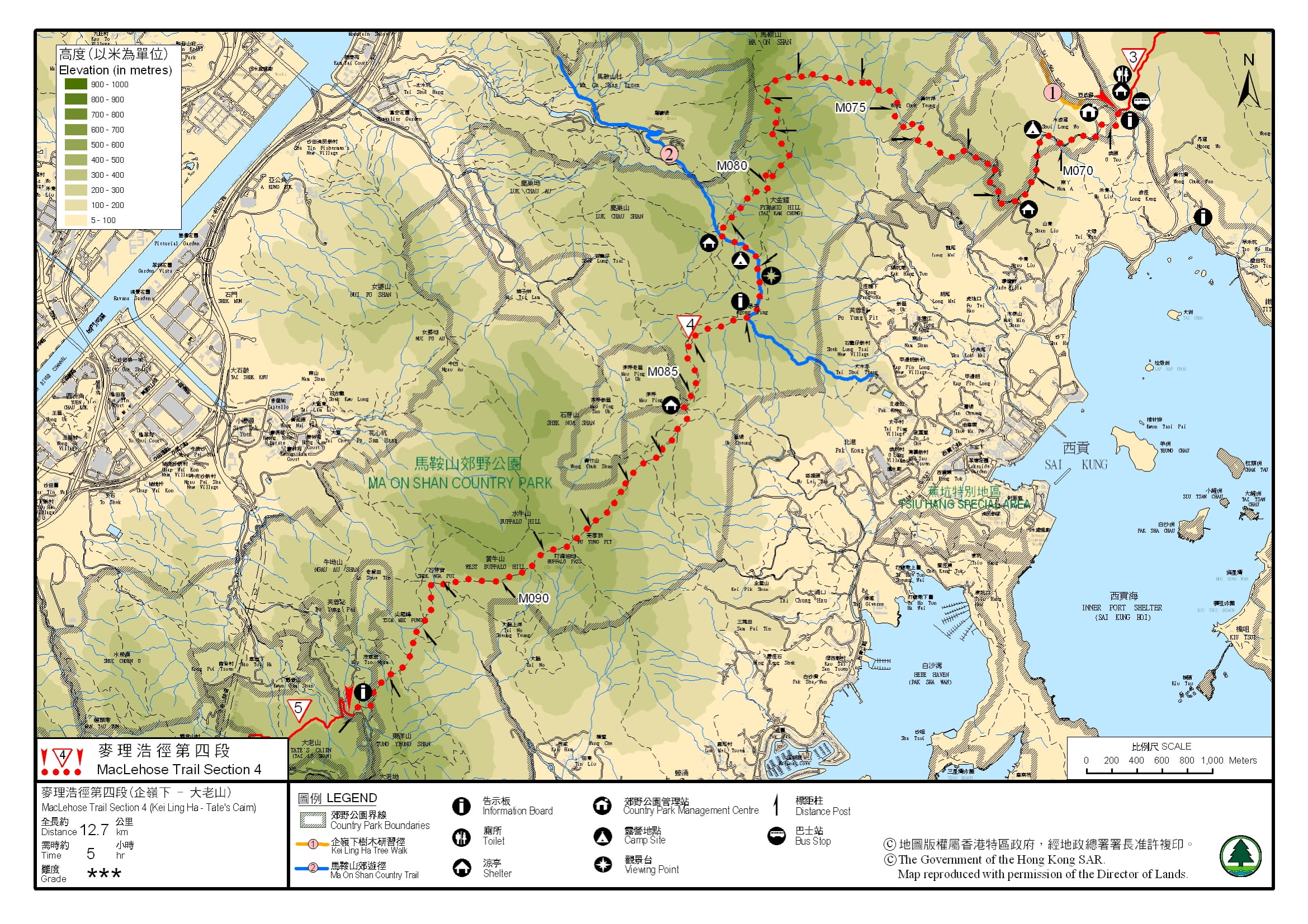
 Map 「MacLehose Trail (Section 4)」路線Map
View :
Difficulty :
Path :
Length : 12.6km
Estimate : 5hours
【 Ngong Ping Campsite(Ma On Shan) 】
Toilet : Outhouse
Water : Stream Water
Ascent : 729m  Descent : 482m  Max : 554m  Min : 72m<br><p class='smallfont'>The accuracy of elevation is +/-30m

Ascent : 729mDescent : 482m
Max : 554mMin : 72m
(The accuracy of elevation is +/-30m)  
Section :
 
Trail 80%
Stairs 10%
Road 10%
Slope :
 
Ascent 729m (60%)
Descent 482m (40%)
Exposure :
 
70%
Climb :
 
 
Start Point :
Bus Taxi 
Support :
 
 
End Point :
Taxi 
 ©2024 一起行山闖蕩去 TimHiking.com


10︰Fire Lookout was built in 1983. There is a radio station next to it and two trigonometrical stations.
It is very convenient to get to the starting point of MacLehose Trail (Section 4).


 ©2024 一起行山闖蕩去 TimHiking.com
Walk for about an hour to an open scenery location. Ma On Shan is on the front


 ©2024 一起行山闖蕩去 TimHiking.com
Already halfway through, continue on the bifurcated road,


 ©2024 一起行山闖蕩去 TimHiking.com


 ©2024 一起行山闖蕩去 TimHiking.com


TimHiking【MacLehose Trail (Section 4)】Hong Kong Hiking Map


Official Map

Official Map
Sky :請問如果行完第四段,又唔夠體力行第五段,又唔想搭的士,最近可以邊度搭車走? (2021-12-27)
 
那應該經馬路由飛鵝山道落山 😉 (Tim Sir 2021-12-28)
bigbear :Tim Sir,你好,打算麥四逆走,希望舒服過/慳時間體力過順走:的士彩雲直到起點基維爾營(海拔420米)--> 終點水浪窩 (84米),請問如果咁駁入黃牛標+黃牛石城+水牛標, 正常步速,唔知會用多幾多時間,會唔會好chur嚇呢?還是分開行好啲?唔該哂 =) (2021-12-14)
 
看你目標是甚麼?想郊遊還是麥四做時間?那就隨心分開行。 (Tim Sir 2021-12-14)
DF :既然終點較麻煩,乾脆到了大金鐘後,回頭返水浪窩;需時多久? (2021-12-09)
 
那麼多路,何必回頭呢?很多路可以選擇。請按下「等高線」查看路程,並自行估算落山所需時間。 (Tim Sir 2021-12-09)
PiT :你說麥徑4段是麥徑難走的一段,難度是3星,而麥徑3段是第2難走,難度卻是4星,不太明白? 前幾天行完麥徑3段,用了3小時半,是否應該也可以應付4段? (2020-12-26)
 
以前的難度是跟漁農署定的,現在已修正。以現在標準,所有官方徑都是3.5星或以下。而麥2/3/4的難度均差不多,當中以麥3是最難的;麥2是長;麥4坡幅也不少,而且完了也要走很遠才可落山。故此,麥4不能單走,除非CALL的在基維爾離開。不過,如果能完成麥3,基本上可分段完成所有段落。祝你成功! (Tim Sir 2020-12-26)
Pozylambobo :夏季要帶咩配備較好 (2020-05-02)
 
防曬衫、帽或遮、好多好多水、少少糧,短線為主。 (Tim Sir 2020-05-02)

Alias:      Email: 
   

😄
* Photos can only be personal or landscape photos, and group photos are authorized for portrait rights by default. In addition, headshots, dangerous shots, or photos containing promotional elements are not accepted.
* The shared content may be published after revision. The content must be absolutely positive. If it does not meet the standards, the content will be deleted.
* The message will be approved within one day, and the final decision-making authority will be reserved for TimHiking.

 Thanks a lot! Hope our hiking information is helpful to you. Everyone is happy to go hiking and safely!
 Welcome to use  Payme   AlipayHK  to sponsor Tim Sir's efforts! Continue to give selflessly for the mountain world.

智慧從何處來呢?聰明之處在哪裏呢?

約伯記 28:20