一起行山闖蕩去

Wong Chuk Kok Tsui
Devil's Fist

Wong Chuk Kok Tsui, Devil's Fist  Login can add to my Favorite

 2020-03-25
 Total Views: 163,152     (Last Updated︰2021-07-24)
 Map 「Wong Chuk Kok Tsui, Devil's Fist」路線Map
View :
Difficulty :
Path :
Length : 29.6km
Estimate : 12hours
Ascent : 965m  Descent : 1,041m  Max : 301m  Min : 0m<br><p class='smallfont'>The accuracy of elevation is +/-30m

Ascent : 965mDescent : 1,041m
Max : 301mMin : 0m
(The accuracy of elevation is +/-30m)  
Section :
 
Trail 60%
Road 10%
Jungle 10%
Gravel 20%
Slope :
 
Ascent 965m (48%)
Descent 1,041m (52%)
Exposure :
 
90%
Climb :
 
 
Start Point :
Bus Minibus Taxi 
Support :
 
 
End Point :
Bus Minibus Taxi 
 ©2024 一起行山闖蕩去 TimHiking.com


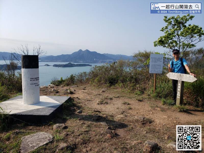
16︰Ma Tau Fung is 295 meters high and there is a trigonometrical station on the top, also a wooden signpost
To save time, take a taxi to Wu Kau Tang. Start early to preserve more time is the best strategy.


 ©2024 一起行山闖蕩去 TimHiking.com
22︰It takes less than 100 meters to reach the second peak Chek Ma Tau.
Along the gravel trail down the mountain,


 ©2024 一起行山闖蕩去 TimHiking.com
49︰There is a location nearby which can have an unobstructed bird's eye view of the entire Plover Cove Reservoir.
After 300 meters, will see a danger warning sign,


 ©2024 一起行山闖蕩去 TimHiking.com
59︰and soon come to the highest point of Dit Sei Kau.
Section 2 starting from the corner of Luk Wu Tung, can see a very obvious barren trail,


 ©2024 一起行山闖蕩去 TimHiking.com
69︰This time keep to the left and go straight because there is an ingenious location that needs to describe in detail.
After landing at Dit Sei Kau, it is a relatively flat grass.


 ©2024 一起行山闖蕩去 TimHiking.com
86︰Go to a completely empty place, which is Fung Wong Tau,
Go straight along ribbon trail on the left,


 ©2024 一起行山闖蕩去 TimHiking.com
100︰Finally, when coming to the last mountain of Wong Chuk Kok Tsui,
About 15 minutes later, come to a piece of sand.


 ©2024 一起行山闖蕩去 TimHiking.com
117︰The rocks are uneven, if the tide rises, the difficulty will be greatly increased.
Bundle along the shore,


 ©2024 一起行山闖蕩去 TimHiking.com
143︰around 10.5km away from Tai Mei Tuk, and it takes about 3.5 hours.
Firstly edge climbs back to the mountain trail,


 ©2024 一起行山闖蕩去 TimHiking.com
Continue along the mountain trail


 ©2024 一起行山闖蕩去 TimHiking.com


 ©2024 一起行山闖蕩去 TimHiking.com


TimHiking【Wong Chuk Kok Tsui . Devil's Fist】Hong Kong Hiking Map

           
AKKK :
今日晚了1020才烏蛟騰出發,好在1900天黑齊前出返郊遊徑,最後11:32:00完成。7小時完成的人好勁啊 (2024-03-28)
 
犀利!super 😉 (Tim Sir 2024-03-28)
ConnieT :Tim Sir, 潮水退到哪個高度才可以不用濕腳摸鬼手? (2022-11-08)
 
理想為1.0米以下。 (Tim Sir 2022-11-09)
男人愛高達 :
感謝Tim Sir分享,星期二大約十二點就到了鬼手岩,潮漲在1.2米左右,但已經可以在鬼手傍打卡,現在有網上離線地圖加參考tim sir筆記,路線不是太大問題,但那天到訪鬼手岩遇上無風大太陽,回程就變得極度辛苦,回程不停休息,用了十二小時才到大尾篤巴士站。很想想像在4-10月行走這條路線。 (2022-03-03)
 
NICE TRIP! 😉 (Tim Sir 2022-03-03)
jim :Hello Tim, 多謝你的照片及路線,你行山路線照片的適切性和數量是同類型網站較好的。關於這路線,想問一下,若這二星期出發,跌死狗後有多長距離有密林的樹枝咭腳?因我以前走餓死雞及走馬岡小腿都大量刮傷(我穿短褲行走山的)。另,全走30公里10小時似乎有點鬆,是給初行山的預算嗎?8至8.5小時可以嗎? (2021-12-22)
 
穿短褲要加小腿Tight,刮是必然的。快是無標準的,真跑我見過7.5小時。 (Tim Sir 2021-12-22)
klfrank930 :
報告Tim sir 人生第六次鬼手終於零的突破~終於九小時半內用密步完成~不冎另外其實如果要加難度可以由綑邊由鬼手去火紅海岸先上返昂莊山… (2021-12-09)
 
棒棒呀!全走加火紅海岸比較難預時間,半走CALL船會好些。 (Tim Sir 2021-12-10)
Lemon :Tim sir,我同朋友plan23/4行, 但想知幾高水位就不能出鬼手? (2021-04-03)
 

如圖,要盡早到,盡快離開。 (Tim Sir 2021-04-03)
Step :你好. Tim Sir. 黃竹角咀於早幾年已是我夢寐以求想去的地方. 這幾年不段訓練能力就是想去這個地方. 但到現時仍尚未出發. 昨日試行了一轉船灣淡水湖打算對路型和長度有個初步了解. 用了7.5小時連休息完成. 想問由鹿湖峒開始到鬼手和鬼手返回鹿湖峒要幾多時間左右 ?? 希望預計一下時間再加思考計劃才出發. 謝謝. (2021-03-11)
 
以你的速度,來回出咀你預6小時。努力!成功後,記得上來報告一下。 (Tim Sir 2021-03-11)
Aaron :
Tim sir既資料真係好詳盡, 成功完成,Thank you Tim Sir!
不過圖中呢個位, 跟絲帶行就行左我呢條路
(2021-03-02)
 
跟錯絲帶無所謂,最緊要是當時知道偏離主線中,而偏離位置也沒打緊,都可接回主線便行。
記住︰路是死的,人是生的😉;監察路線,隨機應變😄;開心上山,安全落山😍!
(Tim Sir 2021-03-02)
Yakman :若不是要堅持一定要完全環湖, 其實可省去橫嶺的一段船灣淡水湖郊遊徑, 改由烏蛟騰沿古道去下苗,才上山到大峒,這樣走法路線長度沒有減很多,但就可減一些上落山 (2021-01-13)
 
是的,不過通常行得鬼手都有一定堅持,不然就半走搭大飛吧! (Tim Sir 2021-01-13)
Nire :Tim sir 想請教下,查看天文台潮汐預報,官網上可查的地點有限。請問鬼手位置應該以那個㸃為準或較近呢?高流灣? 大埔滘? 因為要知道潮漲大約水位及時間才能計劃出咀鬼手的行程,否則是綑不到過去的。謝謝! (2021-01-07)
 
不會的,香港那麼小,選擇同方向最近的就差不了多少。以及,天文台都只是預測來的,實際都會有出入的。 (Tim Sir 2021-01-07)

Alias:      Email: 
   

😄
* Photos can only be personal or landscape photos, and group photos are authorized for portrait rights by default. In addition, headshots, dangerous shots, or photos containing promotional elements are not accepted.
* The shared content may be published after revision. The content must be absolutely positive. If it does not meet the standards, the content will be deleted.
* The message will be approved within one day, and the final decision-making authority will be reserved for TimHiking.

 Thanks a lot! Hope our hiking information is helpful to you. Everyone is happy to go hiking and safely!
 Welcome to use  Payme   AlipayHK  to sponsor Tim Sir's efforts! Continue to give selflessly for the mountain world.

我心裏多憂多疑,你安慰我,就使我歡樂。

詩篇 94:19