


New Routes

Po Kwu Wan,
Pai Tau TunView : 
Difficulty : 
Path : Pak Tam Chung ➡ Sheung Yiu ➡ Hei Tsz Wan ➡ Po Kwu Wan ➡ Sheung Yiu… Length : 6.8 km Time : 4 hours Po Kwu Wan is located in a bay on the west side of Sai Kung Pak Tam Chung High Island Reservoir and Pai Tau Tun. Its vil…
Total Views: 103,244
Po Kwu Wan
View : Difficulty : 
Path : Pak Tam Chung ➡ Sheung Yiu ➡ Hei Tsz Wan ➡ Po Kwu Wan ➡ Sheung Yiu… Length : 7.6 km Time : 2½ hours Po Kwu Wan is located in the northwest of Sai Kung Pak Tam Chung High Island Reservoir. There used to be a village, but …
Total Views: 91,996
Tseung Kwan O Lunar New Year Horse
View : 
Difficulty : 
Path : Tiu Keng Leng Station ➡ Hong Kong Velodrome ➡ Tseung Kwan O Centre… Length : 11.9 km Time : 2½ hours This route, themed 'Good Fortune in the Year of the Horse', will trace a small horse pattern in Tseung Kwan O, covering …
Total Views: 21,051
Miu Tsai Tun,
High Junk Peak,
Tin Ha ShanView : Difficulty : 
Path : Ng Fai Tin ➡ Sheung Yeung Shan ➡ Ha Yeung Shan ➡ Miu Tsai Tun ➡ Hi… Length : 6.8 km Time : 5 hours Sheung Yeung Shan, Ha Yeung Shan, Miu Tsai Tun, High Junk Peak, and Tin Ha Shan are all located on the Sai Kung Clear Wa…
Total Views: 12,283
Tin Ha Shan
View : Difficulty : 
Path : Ng Fai Tin ➡ Sheung Yeung Shan ➡ Ha Yeung Shan ➡ Miu Tsai Tun Moun… Length : 6.6 km Time : 3½ hours Tin Ha Shan is located on the Clear Water Bay Peninsula in Sai Kung, with an elevation of 274 meters. It belongs to the …
Total Views: 15,247
Lin Fa Shan,
Shek Lung Kung,
Ha Fa ShanView : 
Difficulty : Path : Route Twisk ➡ MacLehose Trail (Section 9) ➡ Pat Heung Fire Lookout… Length : 9 km Time : 4½ hours Lin Fa Shan, Shek Lung Kung, and Ha Fa Shan are all located in the mountains south of MacLehose (Section 9) and northwes…
Total Views: 149,527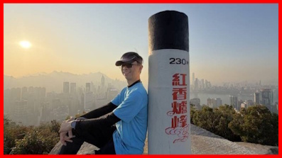
Hung Heung Lo Fung
View : Difficulty : 
Path : Tai Hang Lin Fa Kung Temple ➡ Lai Tak Tsuen ➡ Ma Shan Tsuen ➡ Hung… Length : 1.9 km Time : ¾ hours Hung Heung Lo Fung, at an altitude of 230 meters, is near Braemar Hill on Hong Kong Island. It's very close to the city …
Total Views: 9,602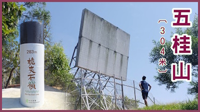
Black Hill,
Wai Kap Shek LengView : Difficulty : 
Path : Lei Yue Mun Estate ➡ Lingnan Template ➡ O King Road ➡ Wilson Trail… Length : 7.5 km Time : 2½ hours Black Hill, also known as Black Ghost Mountain and Five Ghost Mountain. The Black Hill Main Peak is 304 meters high, and…
Total Views: 98,858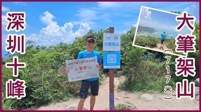
Shenzhen Ten Peaks Dabijiashan
View : Difficulty : Path : Baishawan Park ➡ Sanganbi ➡ Hankeng Rest Area ➡ Dabijiashan ➡ Hank… Length : 8.2 km Time : 5½ hours Shenzhen Dabijiashan is 717 meters above sea level. It is located in Baguang, east of Shenzhen, at the junction of Shenz…
Total Views: 24,966
In the multitude of my thoughts within me thy comforts delight my soul.
Psalms 94:19
Hot Routes (Last 7 days)

Wan Kuk Shan
View : 
Difficulty : Path : Shui Long Wo ➡ Star Lookout ➡ MacLehose Trail (Section 4) ➡ Shui L… Length : 10.4 km Time : 4.5 hours Wan Kuk Shan is 592 meters high, located between Ma On Shan and Pyramid Hill, with MacLehose Trail besides. Its mountain…
Total Views: 504,287
West Buffalo Hill,
Buffalo Hill,
West Buffalo Stone CityView : Difficulty : Skip Stone CityPath : Wong Nai Tau ➡ Fa Sam Hang ➡ Shek Nga Pui ➡ West Buffalo Hill ➡ We… Length : 6.8 km Time : 4 hours West Buffalo Hill, Buffalo Hill is located between Shatin and Sai Kung, connecting with Shek Nga Shan, forming a ridge. …
Total Views: 484,160
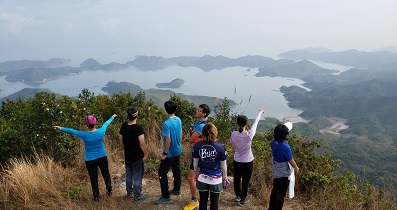
Lung Ha Wan Country Trail
View : Difficulty : Path : Tai Au Mun ➡ Tai Hang Tun ➡ Tai Leng Tung ➡ Ping Tok Hang Shan ➡ L… Length : 2.4 km Time : 2.5 hours Lung Ha Wan Country Trail is located in Tai Au Mun, starting near Tai Au Mun Barbecue Area and ending at Lung Ha Wan. On…
Total Views: 513,124
Kai Kung Leng,
Kai Kung ShanView : Difficulty : Path : Fung Kat Heung ➡ Kai Kung Shan ➡ Ngo Tau Rock ➡ Fairy Dressing Roc… Length : 6.6 km Time : 3 hours Kai Kung Leng is a mountain ridge located within the Lam Tsuen Country Park. It includes Tai Lo Tin (572m), Lo Tin Teng …
Total Views: 482,700
Tai Lam Chung Reservoir,
Wong Nai Chung ReservoirView : Difficulty : Path : So Kwun Wat ➡ So Kwun Wat Tsuen Road ➡ MacLehose Trail (Section 10… Length : 8.2 km Time : 3 hours Reservoir Islands Viewpoint was completed in early 2019. It is the best official place to view Tai Lam Chung Reservoir. …
Total Views: 513,184
Pak Kong Ancient Trail,
Mau PingView : Difficulty : Path : Pak Kong ➡ Pak Kong Ancient Trail ➡ Bamboo Tunnel ➡ Mau Ping ➡ The… Length : 5.4 km Time : 2 hours This route is a short route, it does not need to climb any peak, but there are beautiful and rare tree scenes, mainly to…
Total Views: 356,851
Yuk Kwai Shan,
Ap Lei PaiView : 
Difficulty : edge climbing return to the starting pointPath : Lei Tung Station ➡ Yuk Kwai Shan ➡ Tombolo ➡ Ap Lei Pai ➡ Lighthou… Length : 4.4 km Time : 3.5 hours Yuk Kwai Shan is 196 meters high which is the highest mountain in Ap Lei Chau and located in the south of Lei Tung Estat…
Total Views: 376,754
Tuen Mun Trail,
Lam Tei ReservoirView : Difficulty : Path : Tuen Mun Station ➡ Hon Fuk Tong Centre ➡ Tuen Mun Trail ➡ Rainbow … Length : 5.8 km Time : 2 hours Tuen Mun Trail is located in the centre of Tuen Mun. It only takes 5 minutes to walk from Tuen Mun Station to the entran…
Total Views: 409,894
Sunset Peak Yi Tung Shan Sky Pool
View : Difficulty : Path : Pak Kung Au ➡ Lantau Trail (Section 2) ➡ Springboard Rock ➡ Sunset… Length : 9.4 km Time : 6 hours This time will take a tour of Sunset Peak, Yi Tung Shan and Sky Pool, all located in the eastern part of Lantau. Sunset …
Total Views: 295,810
Protect me from harm; keep an eye on me like you would a child reflected in the twinkling of your eye. Yes, hide me within the shelter of your embrace, under your outstretched wings.
Psalms 17:8 TPT
Today's History

Beacon Hill Gully,
Lion Rock's Ancient KilnView : Difficulty : Path : Phoenix House ➡ Beacon Hill Gully ➡ Kowloon Au ➡ Garter Pass ➡ Siu… Length : 6.1 km Time : 3.5 hours Beacon Hill Gully is a natural gully located south of Beacon Hill in Hong Kong. Due to the long-term erosion of rainwate…
Total Views: 30,394
Lai Chi Chong
View : Difficulty : Path : Pak Sha O ➡ Ho's House ➡ Nam Shan Tung ➡ Lai Chi Chong ➡ Tai Pak K… Length : 4.1 km Time : 1.5 hours Lai Chi Chong is a Hakka village with a long history, located on the south bank of Tolo Channel between Hoi Ha and Sham …
Total Views: 41,342
High Junk Peak Country Trail
View : Difficulty : leave at Ha Shan TukPath : Ng Fai Tin ➡ Sheung Yeung Shan ➡ Ha Yeung Shan ➡ Miu Tsai Tun Moun… Length : 6.3 km Time : 3 hours High Junk Peak Country Trail is located on Sai Kung Clear Water Bay Peninsula. The trail runs from Ng Fai Tin across the…
Total Views: 262,200
No.12 Hill,
Quarry Hill,
Red Light HillView : 
Difficulty : 
Path : Ho Man Tin Station ➡ King's Park High Level Service Reservoir ➡ No… Length : 3.5 km Time : 1.5 hours No.12 Hill, also known as Hung Hom Shan, 84 meters high, is located on a low hill in Ho Man Tin, which is currently the …
Total Views: 112,154
Little Hawaii Trail,
Lin Yuen Toi FallsView : Difficulty : Path : Po Lam ➡ Ying Ming Court ➡ Po Hang Path ➡ Lin Yuen Toi Falls ➡ Lit… Length : 3.7 km Time : 1.5 hours Little Hawaii is located on the mountain trail between Tseung Kwan O and Tseng Lan Shue. It is the yard of Tseung Kwan …
Total Views: 194,326
TimHiking Winged Baby Dinosaur
View : Difficulty : Path : Kennedy Town ➡ Pokfield Road ➡ Lung Fu Shan ➡ Victoria Peak Garden… Length : 23.5 km Time : 6 hours This route will draw a Winged Baby Dinosaur on the west side of Hong Kong Island, hence the name 'TimHiking Winged Baby …
Total Views: 68,976
Mars Cave,
Twist CaveView : Difficulty : Path : Clear Water Bay Second Beach ➡ Ha Shan Tuk ➡ Mars Cave ➡ Twist Cav… Length : 5.5 km Time : 3 hours Mars Cave and Twist Cave are located on the coast of Ha Shan Tuk to the east of Clear Water Bay Peninsula, which is also…
Total Views: 74,708
Braemar Hill,
Po Luen Path,
Aroma WalkView : Difficulty : Path : Quarry Bay Station ➡ Po Luen Path ➡ Braemar Hill ➡ Sir Cecil's Rid… Length : 3.8 km Time : 1.5 hours Braemar Hill is 200 meters high, located to the northeast of Hung Heung Lo Fung, to the north of Siu Ma Shan, very close…
Total Views: 90,390
Shouson Hill
View : Difficulty : Path : Nam Fung Road ➡ Deep Water Bay Road ➡ Shouson Hill ➡ Shouson Hill … Length : 2.7 km Time : 1.5 hours Shouson Hill is 148 meters high. It is located on a small hill between Wong Chuk Hang and Deep Water Bay in the southern…
Total Views: 48,372
He has forgiveness for all your sins; he takes away all your diseases;
Psalms 103:3 BBE
Random Routes
Tiu Tang Lung,
Fan Kei TokView : Difficulty : Path : Wu Kau Tang ➡ Kau Tam Tso ➡ Lai Sam Ancient Trail ➡ Tiu Tang Lung … Length : 10.2 km Time : 5 hours Tiu Tang Lung at an altitude of 416 meters, located in the New Territories north of Plover Cove Reservoir, south of Lai …
Total Views: 119,498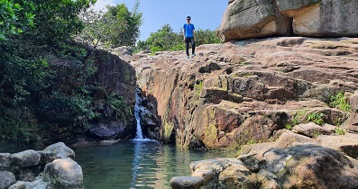
Siu Ma Stream,
Hung Heung Lo FungView : Difficulty : Path : Quarry Bay Station ➡ Po Luen Path ➡ Siu Ma Stream ➡ Si Yau Pavilio… Length : 6.5 km Time : 2.5 hours The water source of Siu Ma Stream comes from Siu Ma Shan, it is the north stream of Siu Ma Shan. The whole stream is bas…
Total Views: 89,284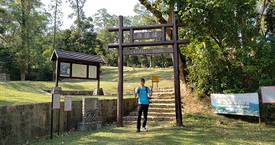
Lantau Trail (Section 1)
View : 
Difficulty : Path : Mui Wo Pier ➡ South Lantau Road ➡ Nam Shan Length : 2.3 km Time : 0.75 hours Lantau Trail is an official trail around Lantau Island, 70km in length, divided into twelve sections. Lantau Trail (Sect…
Total Views: 41,664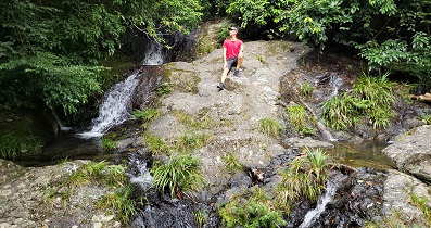
Kap Lung Ancient Trail Country Trail
View : Difficulty : Path : Liu Kung Tin ➡ Kap Lung Ancient Trail ➡ Route Twisk Length : 1.9 km Time : 1 hours Kap Lung Ancient Trail is one of the hillsides to the west of Tai Mo Shan. It can travel between Liu Kung Tin and Route …
Total Views: 78,689
Our Lady of Joy Abbey,
Man Kok TsuiView : Difficulty : skipping Man Kok TsuiPath : Discovery Bay ➡ Nim Shue Wan ➡ Tai Shui Hang ➡ Our Lady of Joy Abb… Length : 10.8 km Time : 3.5 hours Our Lady of Joy Abbey is located in Tai Shui Hang on Lantau Island, between Nim Shue Wan Village and the top of Tai Shui…
Total Views: 55,388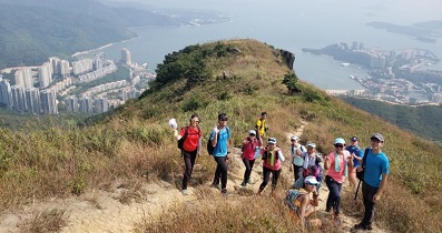
Lo Fu Tau
View : Difficulty : Path : Discovery Bay Pier ➡ Parkvale Drive ➡ Discovery Bay Viewing Point … Length : 5.9 km Time : 4 hours Lo Fu Tau is located to the west of Discovery Bay, at a high altitude of 465 meters. The mountain is as its name, and th…
Total Views: 94,905Lung Ha Wan Country Trail
View : Difficulty : Path : Tai Au Mun ➡ Tai Hang Tun ➡ Tai Leng Tung ➡ Ping Tok Hang Shan ➡ L… Length : 2.4 km Time : 2.5 hours Lung Ha Wan Country Trail is located in Tai Au Mun, starting near Tai Au Mun Barbecue Area and ending at Lung Ha Wan. On…
Total Views: 513,124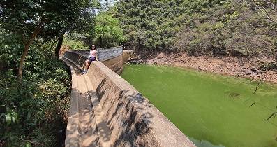
Ngau Wu Reservoir
View : Difficulty : BacktrackPath : Kam Ying Court ➡ Ngau Wu Reservoir ➡ Ma Mei Rridge ➡ Ma On Shan By… Length : 2.7 km Time : 1.25 hours Ngau Wu Reservoir is located at the lower reaches of Ngau Wu Stream in Ma On Shan. It was originally a private storage w…
Total Views: 43,957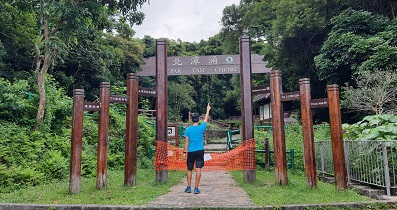
Pak Tam Chung Family Trail
View : 
Difficulty : Path : Pak Tam Chung Car Park ➡ Tsak Yue Wu Length : 1.4 km Time : 0.75 hours Pak Tam Chung Family Trail is located in the largest Barbecue Area in Sai Kung Pak Tam Chung. The whole journey is only …
Total Views: 43,604
Be merciful unto me, O God, be merciful unto me: for my soul trusteth in thee: yea, in the shadow of thy wings will I make my refuge, until these calamities be overpast.
Psalms 57:1